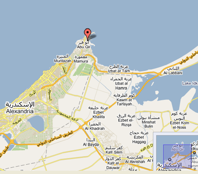
Abu Qir port was originally for sole use of Egyptian Navy when built around 1983, however now same handles significant commercial traffic, mainly small general cargo and bulk carriers.It is situated on Mediterranean approximately 20 km North East of Alexandria.
| Port Position Long | 030º 04 E | |
| Port Position Lat | 31º 19’ 20’’ N | |
| Time Zone | GMT +2 (+/- hours) | |
| Nearest Airport | Alexandria | |
| Authority | Abu Qir Port Authority | |
| Max LOA | 200 Ft | |
| Night Navigation | 29 Ft | |
| Tides | Normally about 0.20m but up to 0.40m | |
| Weather | Variable prevailing winds, strongest from north west |
Facilities: |
|
Services: |
||
|
Tanker |
|
|
Crew Change |
|
|
Liquid |
|
|
Visa |
|
|
Gas |
|
|
Road Transport |
|
|
RoRo |
|
|
Personnel Transport |
|
|
Multipurpose |
|
|
Floating Crane |
|
|
Break bulk |
|
|
Tug |
|
|
Container |
|
|
Warehouse Storage |
|
|
Dry Bulk |
|
|
Fresh Water |
|
|
Passenger |
|
|
Medical Treatment |
|
|
|
|
|
Travel Agency |
|
|
|
|
|
Survey |
|
|
|
|
|
Underwater Cleaning |
|
|
|
|
|
Provisions |
|
|
|
|
|
Dry-dock |
|
|
|
|
|
Bunkers |
|
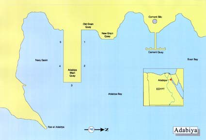
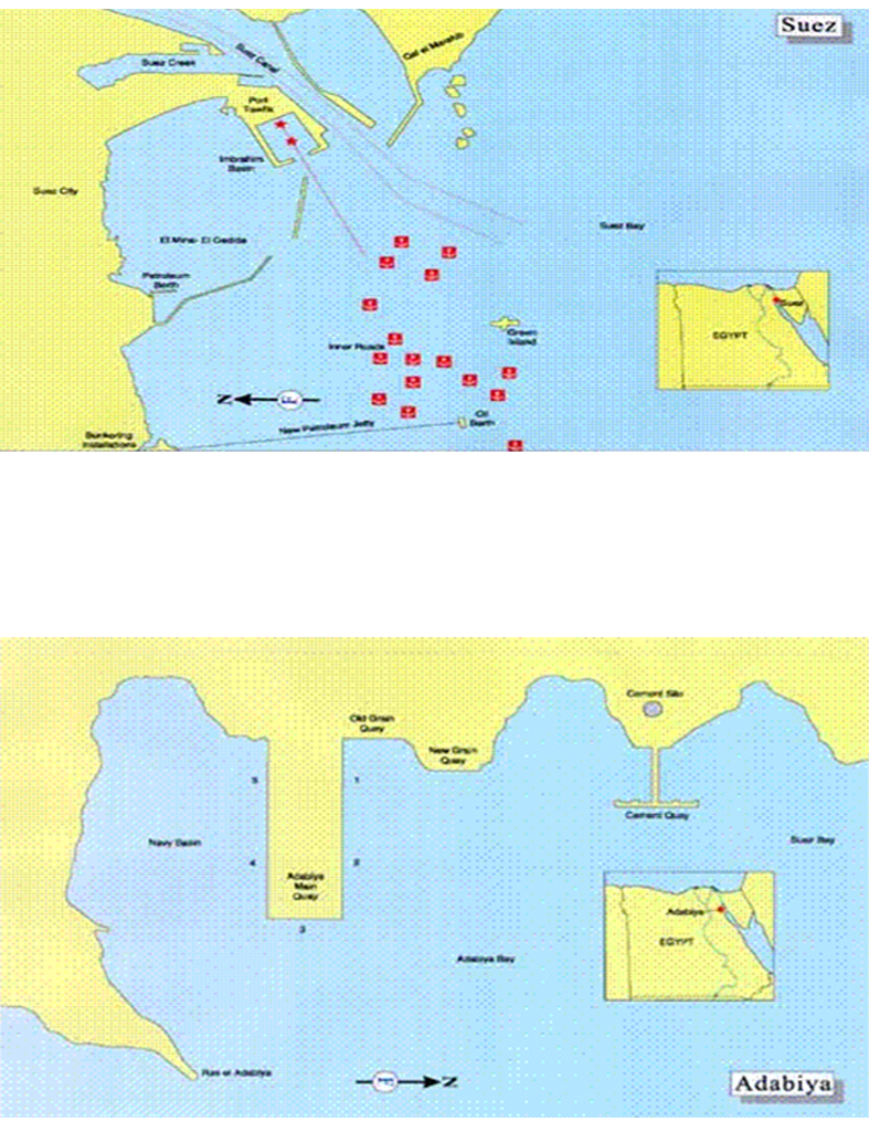
Adabiya port is situated on the western coast of Suez Gulf, and is 17 km. away from Suez City. It consists of 9 berths with estimate length of 1840 m. and draft between 27 and 42 feet Naval vessels are also using this port.
| Port Position Long | 32º 29 E | |
| Port Position Lat | 29º 52 N | |
| Terminal Type | Dry Bulk | |
| Time Zone | GMT +2 (+/- hours) | |
| Nearest Airport | Suez Airport | |
| Authority | Red Sea Ports Authority | |
| Max Draft | 42 feet | |
| Max Length | 200 m | |
| Main Import | General Cargo | |
| Main Export | General Cargo | |
| Navigation | Night Navigation allowed | |
| Tides | Tide range between 1.2m and 2.1m | |
| Weather | Prevailing winds are north and north west | |
| Working Hours | 24 hours per day |
Facilities: |
|
Services: |
||
|
Tanker |
|
|
Crew Change |
|
|
Liquid |
|
|
Visa |
|
|
Gas |
|
|
Road Transport |
|
|
RoRo |
|
|
Personnel Transport |
|
|
Multipurpose |
|
|
Floating Crane |
|
|
Break bulk |
|
|
Tug |
|
|
Container |
|
|
Supply Boat |
|
|
Dry Bulk |
|
|
Warehouse Storage |
|
|
Passenger |
|
|
Fresh Water |
|
|
|
|
|
Medical Treatment |
|
|
|
|
|
Survey |
|
|
|
|
|
Underwater Cleaning |
|
|
|
|
|
Provisions |
|
|
|
|
|
Dry-Dock |
|
|
|
|
|
Dirty Ballast Reception |
|
|
|
|
|
Bunkers |
|
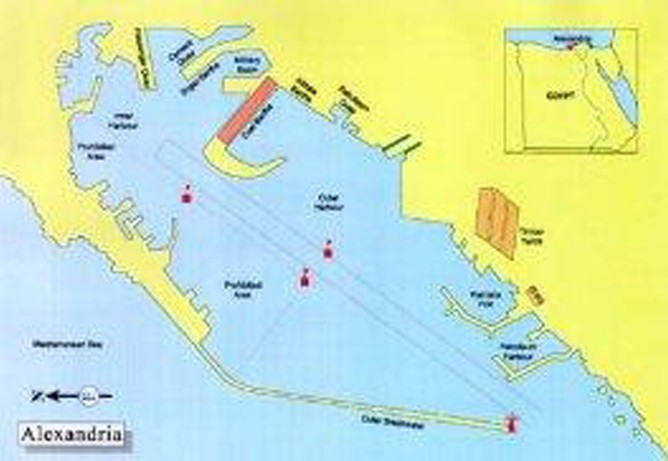
Alexandria is situated on the north coast of Egypt approximately 220 kilometers from Cairo. Alexandria is the principal port in Egypt and It handles over three quarters of Egypt’s foreign trade. Alexandria port consists of two harbors (East and West) separated by a T-shaped peninsula. The East harbor is shallow and is not used in navigation (used by fishing boats and yachts) and West harbor for commercial shipping. The entrance channel is 500 meters wide.
| Port Position Long | 29º 52 E | |
| Port Position Lat | 31º 11 N | |
| Terminal Type | Container Type, Vegetables Oil terminal, Molasses terminal, Grain terminal, Coal terminal, Petroleum terminal | |
| Time Zone | GMT +2 (+/- hours) | |
| Nearest Airport | Alexandria, Borg El Arab | |
| Authority | Alexandria Port Authority, 106 El Horreya Street, Alexandria | |
| Max Draft | 12.8 M | |
| Max Length | 4.8 Km | |
| Max Ship size | Approx. 150,000 Tons | |
| Main Import | Dry bulk cargo, General cargo, Liquid bulk cargo | |
| Main Export | General cargo, Oil products | |
| Navigation | Night Navigation allowed except for Vegetables oil terminal and petroleum terminal. | |
| Tides | Occurs from 0,3 to 0,45 meters | |
| Weather | Prevailing wind occurs North Eastern 2-3 ms during summer season 4-7 ms during winter season | |
| Working Hours | 24 hours per day/7 days a week |
Facilities: |
|
Services: |
||
|
Tanker |
|
|
Crew Change |
|
|
Liquid |
|
|
Crew Change |
|
|
Gas |
|
|
Visa |
|
|
RoRo |
|
|
Road Transport |
|
|
Multipurpose |
|
|
Personnel Transport |
|
|
Break bulk |
|
|
Floating Crane |
|
|
Container |
|
|
Tug |
|
|
Dry Bulk |
|
|
Supply Boat |
|
|
Passenger |
|
|
Warehouse Storage |
|
|
|
|
|
Fresh Water |
|
|
|
|
|
Medical Treatment |
|
|
|
|
|
Travel Agency |
|
|
|
|
|
Air Freight Clearance |
|
|
|
|
|
Sea Freight Clearance |
|
|
|
|
|
Survey |
|
|
|
|
|
Underwater Cleaning |
|
|
|
|
|
Provisions |
|
|
|
|
|
Dry-Dock |
|
|
|
|
|
Dirty Ballast Reception |
|
|
|
|
|
Bunkers |
|
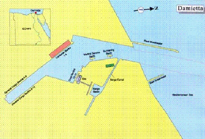
Damietta Port is situated 10.5 km west of the Nile river of Damietta branch westward Ras El-Bar, and 70 km away from Port Said Port. The port installations extend on an area of 11.8 sq. Km. The port is bordered by an imaginary line connecting the eastern and western external breakwaters.The port is covered by two breakwaters. The port consists of 14 berths and additional berths for smaller vessels.
| Port Position Long | 32º 28 E | |
| Port Position Lat | 29º 52 N | |
| Terminal Type | Dry Bulk, General Cargo ,Containers and LNG. | |
| Time Zone | GMT +2 (+/- hours) | |
| Nearest Airport | Cairo Airport | |
| Authority | Damietta Authority | |
| Max Draft | 10,5 M – 14.5 M | |
| Max Length | 200 m | |
| Main Import | General Cargo | |
| Main Export | General Cargo | |
| Navigation | Night Navigation allowed | |
| Tides | Tide range between 1.2m and 2.1m | |
| Weather | Prevailing winds are north and north west | |
| Working Hours | 24 hours per day |
Facilities: |
|
Services: |
||
|
Tanker |
|
|
Crew Change |
|
|
Liquid |
|
|
Visa |
|
|
Gas |
|
|
Road Transport |
|
|
RoRo |
|
|
Personnel Transport |
|
|
Multipurpose |
|
|
Floating Crane |
|
|
Break bulk |
|
|
Tug |
|
|
Container |
|
|
Supply Boat |
|
|
Dry Bulk |
|
|
Warehouse Storage |
|
|
Passenger |
|
|
Fresh Water |
|
|
|
|
|
Medical Treatment |
|
|
|
|
|
Travel Agency |
|
|
|
|
|
Sea Freight Clearance |
|
|
|
|
|
Survey |
|
|
|
|
|
Underwater Cleaning |
|
|
|
|
|
Provisions |
|
|
|
|
|
Dry-Dock |
|
|
|
|
|
Dirty Ballast Reception |
|
|
|
|
|
Bunkers |
|
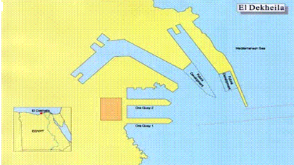
El-Dekheila port is a natural extension to Alexandria Port. it is situated 7 kilometers west of Alexandria and is considered an extension of that port.
| Port Position Long | 29º 48 E | |
| Port Position Lat | 31º 09 N | |
| Terminal Type | Iron Ore Terminal, Coal Terminal, Grain Silos, Medoer Terminal, Container Terminal | |
| Time Zone | GMT +2 (+/- hours) | |
| Nearest Airport | Alexandria, Borg el Arab | |
| Authority | Alexandria Port Authority, 106 El Horreya Street, Alexandria | |
| Max Draft | 18.- M | |
| Max Length | 304,8 m | |
| Max Ship Size | 168,000 mt | |
| Main Import | Coal, Maize, Pallets, Scrap, Soya | |
| Main Export | Salt, Soya, Steel | |
| Navigation | Night Navigation allowed except for Medor Terminal | |
| Tides | Rise varies from 0.3 meters to 0.45 meters | |
| Weather | Prevailing winds from west to northwest, force 2-3 during summer and 4-7 during winter | |
| Working Hours | 24 hours a day / 7 days a week |
Facilities: |
|
Services: |
||
|
Tanker |
|
|
Crew Change |
|
|
Liquid |
|
|
Visa |
|
|
Gas |
|
|
Road Transport |
|
|
Gas |
|
|
Personnel Transport |
|
|
RoRo |
|
|
Floating Crane |
|
|
Multipurpose |
|
|
Tug |
|
|
Break bulk |
|
|
Supply Boat |
|
|
Container |
|
|
Warehouse Storage |
|
|
Dry Bulk |
|
|
Fresh Water |
|
|
Passenger |
|
|
Medical Treatment |
|
|
|
|
|
Sea Freight Clearance |
|
|
|
|
|
Survey |
|
|
|
|
|
Underwater Cleaning |
|
|
|
|
|
Provisions |
|
|
|
|
|
Dry-Dock |
|
|
|
|
|
Dirty Ballast Reception |
|
|
|
|
|
Bunkers |
|
Sidi Kirir Terminal is located approximately 27 kilometers west of Alexandria. The port is the Mediterranean terminal of the Suez-Mediterranean (Sumed) pipeline and used for mooring & shipping of oil tankers and it is exclusively specified for Sumid motorboats, according to a scheme approved by the Minister of Petroleum as a representative of the Egyptian Government. The port is consists of 6 offshore SBM tanker berths.
| Port Position Long | 29º 37 E | |
| Port Position Lat | 31º 06 N | |
| Terminal Type | SBM | |
| Time Zone | GMT +2 (+/- hours) | |
| Nearest Airport | Borg el Arab, Alexandria | |
| Authority | Petroleum Pipelines Co. (SUMED). 431 El Geish Avenue, Loran, Alexandria. | |
| Max Draft Excl Tide | 22,9 m | |
| Max Length | 350 m | |
| Max DWT | 500,000 mt | |
| Main Import | Oil | |
| Navigation | Navigation is not allowed after sunset | |
| Tides | 0.6 m | |
| Weather | Winds till 40 knots | |
| Working Hours | Working 24 Hours/ 7 days a week |
Facilities: |
|
Services: |
||
|
Tanker |
|
|
Crew Change |
|
|
Liquid |
|
|
Visa |
|
|
Liquid |
|
|
Road Transport |
|
|
Gas |
|
|
Personnel Transport |
|
|
RoRo |
|
|
Floating Crane |
|
|
Multipurpose |
|
|
Tug |
|
|
Break bulk |
|
|
Supply Boat |
|
|
Container |
|
|
Warehouse Storage |
|
|
Dry Bulk |
|
|
Fresh Water |
|
|
Passenger |
|
|
Medical Treatment |
|
|
|
|
|
Travel Agency |
|
|
|
|
|
Sea Freight Clearance |
|
|
|
|
|
Survey |
|
|
|
|
|
Underwater Cleaning |
|
|
|
|
|
Provisions |
|
|
|
|
|
Dry-Dock |
|
|
|
|
|
Dirty Ballast Reception |
|
|
|
|
|
Bunkers |
|
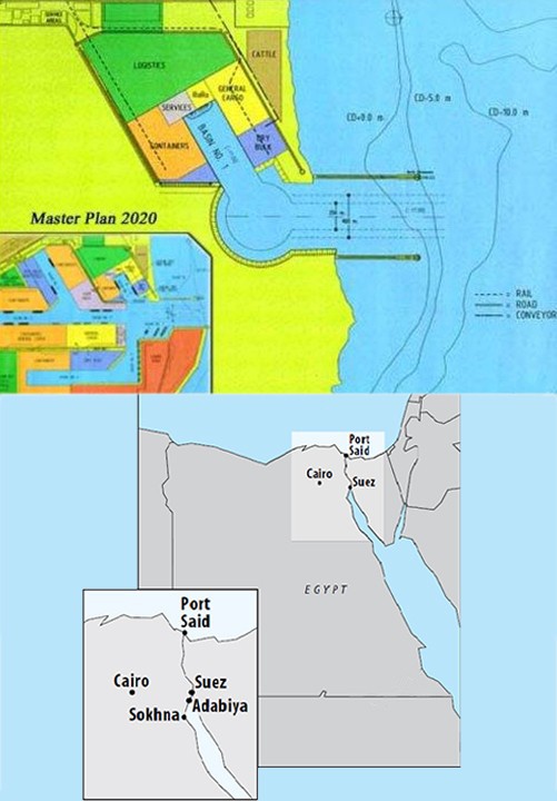
Ain Sokhna port is considered one of the recent ports that were established by B.O.T system. It is the port of 21st century, same managed via logistic centers and considers of the huge national projects. It is also the result of planning, regular executing for an important phase concerning the geographic position of Egypt.It is considered the first comprehensive and multi- purpose hub port. It comes under what is called "Third Generation ports" to serve export and import operations of general cargo, bulk and container handling. It is also equipped with ultimate technology. The port is located on the western coast of Suez gulf, on a distance 22.3 km2 and away from Suez city 43 km.
| Port Position Long | 32º 21.4 / E | |
| Port Position Lat | 29º 39 / N | |
| Terminal Type | General cargo, Bulk Cargo, Containers and RoRo | |
| Time Zone | GMT +2 (+/- hours) | |
| Nearest Airport | Cairo | |
| Authority | Ein El-Sokhna Port, Suez– El-Sokhna, Egypt C/O Red Sea ports Authority. +2 (062) 3710320 - 3710322 | |
| Max Draft | 17 M | |
| Navigation | Night Navigation allowed | |
| Tides | It ranges up to 7 feet with a maximum 0,5 knots at the surface | |
| Weather | It ranges up to 7 feet with a maximum 0,5 knots at the surface Generally good, winds from NW throughout the year. Hot and dry during summer period and cool winter | |
| Working Hours | 24 Hours/Day, Seven days/week |
Facilities: |
|
Services: |
||
|
Tanker |
|
|
Crew Change |
|
|
Liquid |
|
|
Visa |
|
|
Gas |
|
|
Road Transport |
|
|
RoRo |
|
|
Personnel Transport |
|
|
Multipurpose |
|
|
Floating Crane |
|
|
Break bulk |
|
|
Tug |
|
|
Container |
|
|
Supply Boat |
|
|
Dry Bulk |
|
|
Warehouse Storage |
|
|
|
|
|
Fresh Water |
|
|
|
|
|
Medical Treatment |
|
|
|
|
|
Travel Agency |
|
|
|
|
|
Sea Freight Clearance |
|
|
|
|
|
Survey |
|
|
|
|
|
Underwater Cleaning |
|
|
|
|
|
Provisions |
|
|
|
|
|
Dry-Dock |
|
The port of Suez is located at part of Suez Gulf on the southern gate of Suez Canal. The port is sheltered, except from the South. it is bordered by an imaginery line extending from Ras Masala to Ras El-Sadat . It includes the northern coast until Suez Canal entrance.The port consists of Port Ibrahim, Petroleum Dock, Port Tawfic and Ataka Port:Ibrahim Dock: Bordered by an imaginary line extending between the two breakwaters, Accommodating general cargo vessels and passenger vessels.Petroleum Dock: Bordered by an imaginary line extending 140 degrees from the extremity of the eastern breakwater until the western breakwater, Accommodate Tankers.Ataka: The water out of Ataka Port are delimited by the port breakwaters. The water out of the boundaries of Ibrahim Dock, Petroleum Dock, Ataka Port, Adabiya Port and New Petroleum Bert is within the Suez Canal values.Port Tawfik: Accommodating passenger vessels
| Port Position Long | 32º 34 E | |
| Port Position Lat | 29º 56 N | |
| Terminal Type | Multiple | |
| Time Zone | GMT +2 (+/- hours) | |
| Nearest Airport | Cairo | |
| Authority | Port Authority of Suez, Suez Canal Authority | |
| Max Draft | 8.- M – 12.- M | |
| Navigation | Movements of vessels only allowed during the day | |
| Tides | The tides are influenced by season Southern tide rises 2,13 meters Northern tide rises 1,22 meters | |
| Weather | Prevailing winds are north to northwest. Strong winds may occur during spring | |
| Working Hours | Offices are generally open from 0900 to 1400. Harbor workers: 0800-1530 1600-2230 0000-0600 |
Facilities: |
|
Services: |
||
|
Tanker |
|
|
Crew Change |
|
|
Liquid |
|
|
Visa |
|
|
Gas |
|
|
Road Transport |
|
|
RoRo |
|
|
Personnel Transport |
|
|
Multipurpose |
|
|
Floating Crane |
|
|
Break bulk |
|
|
Tug |
|
|
Container |
|
|
Supply Boat |
|
|
Dry Bulk |
|
|
Warehouse Storage |
|
|
|
|
|
Fresh Water |
|
|
|
|
|
Medical Treatment |
|
|
|
|
|
Travel Agency |
|
|
|
|
|
Sea Freight Clearance |
|
|
|
|
|
Survey |
|
|
|
|
|
Underwater Cleaning |
|
|
|
|
|
Provisions |
|
|
|
|
|
Dry-Dock |
|
|
|
|
|
Dirty Ballast Reception |
|
|
|
|
|
Bunkers |
|
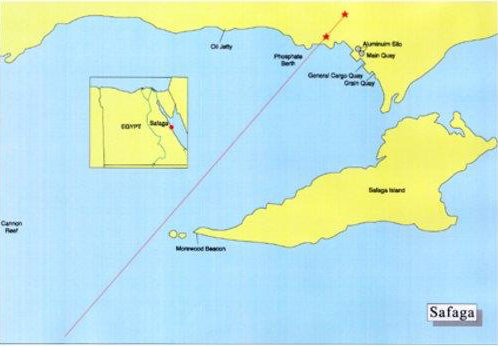
Safaga is situated on the western shore of the Red Sea, midway between Hamrawein and Hurghada.The port is sheltered by an island and reefs and is an important phosphate export terminal.Vessels usually enter the port in the early morning, when the reefs are easily visible.
| Time Zone | GMT +2 (+/- hours) | |
| Nearest Airport | Cairo | |
| Authority | Safaga Port Authority co/ Red Sea ports Authority | |
| Max Draft Excl Tide | From 9 M to 13 M | |
| Max Length | Max LOA 230.- M subject to distance from begining of 1st hold to end of last hold not to exceed 200.- M | |
| Navigation | Only Day light movements allowed | |
| Tides | 1.2 m. to 2.1 m | |
| Weather | Prevailing winds are north west and south east | |
| Working Hours | 24 hours a day |
Facilities: |
|
Services: |
||
|
Tanker |
|
|
Crew Change |
|
|
Liquid |
|
|
Visa |
|
|
Gas |
|
|
Road Transport |
|
|
RoRo |
|
|
Personnel Transport |
|
|
Multipurpose |
|
|
Floating Crane |
|
|
Break bulk |
|
|
Tug |
|
|
Container |
|
|
Supply Boat |
|
|
Dry Bulk |
|
|
Warehouse Storage |
|
|
Passenger |
|
|
Fresh Water |
|
|
|
|
|
Medical Treatment |
|
|
|
|
|
Delivery of spare parts |
|
Sharm El-Sheikh port is 380 km south of Suez GoSharm_El_Sheikh.jpg - 48.62 kBvernorate,156 mile from Suez port and 490 km. from Cairo.It is located on top of the triangle of Sinai Peninsula, at the confluent of Suez and Aqaba Gulfs in South Sinai Governorate.One Passengers quay:Berth Number : 1Length : 628mMaximum Draft : 5-8Number of Bollards : 8
| Port Position Long | 34 º17 / E | |
| Port Position Lat | 27 º 51.2 / N | |
| Terminal Type | Passengers | |
| Time Zone | GMT +2 (+/- hours) | |
| Nearest Airport | Sharm El-Sheikh | |
| Authority | Red Sea Port Authority, Sharm El Sheikh | |
| Max Draft | 26.248 feet | |
| Max Length | 625 m | |
| Navigation | Night Navigation allowed | |
| Tides | 1.3 m. To 2.3 m. | |
| Weather | Prevailing winds are Western and north western winds. | |
| Working Hours | 24 hours per day |
Facilities: |
|
Services: |
||
|
Tanker |
|
|
Crew Change |
|
|
Liquid |
|
|
Visa |
|
|
Gas |
|
|
Road Transport |
|
|
RoRo |
|
|
Personnel Transport |
|
|
Multipurpose |
|
|
Floating Crane |
|
|
Break bulk |
|
|
Tug |
|
|
Break bulk |
|
|
Supply Boat |
|
|
Break bulk |
|
|
Warehouse Storage |
|
|
Container |
|
|
Fresh Water |
|
|
Dry Bulk |
|
|
Survey |
|
|
Passenger |
|
|
Underwater Cleaning |
|
|
|
|
|
Provisions |
|
|
|
|
|
Dry-dock |
|
|
|
|
|
Dirty Ballast Reception |
|
|
|
|
|
Bunkers |
|
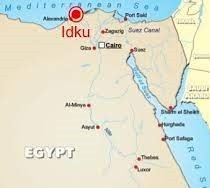
Idku LNG Port is located on Egypt’s Mediterranean Coast on the East of Bay of Abu Qir, 40 km east of Alexandria.The port is managed and operated by port operations department, which offers services to LNG vessels.Supply boats authorized by Port Management to use the port on a regular base for their offshore operations and maintenance.
| Port Position Long | 30° 18’40” E | |
| Port Position Lat | 31° 21’ 7.9” N | |
| Terminal Type | Idku LNG port is the largest specialized LNG export facility in Egypt capable to accommodate the largest LNG vessels up to 160,000 m³. | |
| Time Zone | GMT +2 (+/- hours) | |
| Nearest Airport | Burj Al-Arab | |
| Owner | Egyptian Liquefied Natural Gas Project Alexandria-IDKU Coastal Road El Beheira | |
| Max Draft | Maximum depth 11.7 | |
| Navigation | Available 24 hours a day | |
| Tides | Tidal range: normally about 1.00m | |
| Weather | Winds light in morning, gain strength in day, can be very strong | |
| Working Hours | 24 hours | |
| Pilotage | Vessels arriving from sea shall proceed to pilot boarding area two nautical miles from the channel entrance |
Facilities: |
|
Services: |
||
|
Tanker |
|
|
Crew Change |
|
|
Liquid |
|
|
Visa |
|
|
Gas |
|
|
Road Transport |
|
|
RoRo |
|
|
Personnel Transport |
|
|
Multipurpose |
|
|
Floating Crane |
|
|
Multipurpose |
|
|
Tug |
|
|
Break bulk |
|
|
Supply Boat |
|
|
Container |
|
|
Warehouse Storage |
|
|
Dry Bulk |
|
|
Fresh Water |
|
|
Passenger |
|
|
Medical Treatment |
|
|
|
|
|
Sea Freight Clearance |
|
|
|
|
|
Survey |
|
|
|
|
|
Underwater Cleaning |
|
|
|
|
|
Provisions |
|
|
|
|
|
Dry-dock |
|
|
|
|
|
Dirty Ballast Reception |
|
|
|
|
|
Bunkers |
|
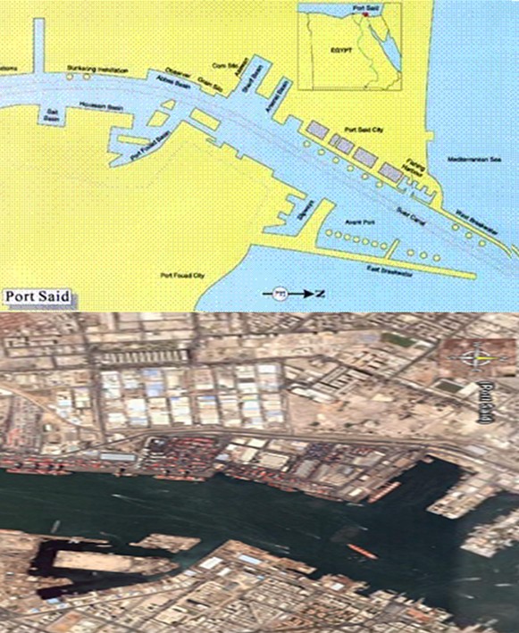
Port Said is situated on the Northern entrance of the Gulf of Suez. It is considered one of the main Egyptian ports due to its distinguished location at the crossroad of the most important world sea trade route between the East and Europe via Suez Canal, and the most extensive transshipment port in the world.A bypass channel has been built east of Port Said in order to avoid large vessels and vessels with dangerous cargo to enter the main Port Said port. It is constructed Between the Mediterranean sea and connects with the canal 17 kilometers south of Port Said.
| Port Position Long | 32º 18 E | |
| Port Position Lat | 31º 15 N | |
| Terminal Type | Container, Passenger, Dry Bulk, and General Cargo, RoRo | |
| Time Zone | GMT +2 (+/- hours) | |
| Nearest Airport | El Gamil | |
| Authority | Port Said Port Authority Moustafa Kamel & Azmey Street, Railway Square, Port Said | |
| Max Draft | 13.20 m | |
| Max Length | 230 M | |
| Max DWT | 68,000 (Dry bulk) mt | |
| Main Import | Agricultural prod, chemicals, metal products, mining machinery, transportation equipment | |
| Main Export | Cotton, garments, rice | |
| Navigation | 24 hour (Night Navigation) | |
| Tides | Rise of tide about 0.30 m | |
| Weather | Normal north west most of the year. Mild weather | |
| Working Hours | 24 hours a day Normal hours 0600-1800. Overtime 1800-0600. |
Facilities: |
|
Services: |
||
|
Tanker |
|
|
Crew Change |
|
|
Liquid |
|
|
Visa |
|
|
Gas |
|
|
Road Transport |
|
|
RoRo |
|
|
Personnel Transport |
|
|
Multipurpose |
|
|
Floating Crane |
|
|
Break bulk |
|
|
Tug |
|
|
Container |
|
|
Supply Boat |
|
|
Dry Bulk |
|
|
Warehouse Storage |
|
|
Passenger |
|
|
Fresh Water |
|
|
|
|
|
Medical Treatment |
|
|
|
|
|
Travel Agency |
|
|
|
|
|
Sea Freight Clearance |
|
|
|
|
|
Survey |
|
|
|
|
|
Underwater Cleaning |
|
|
|
|
|
Provisions |
|
|
|
|
|
Dry-Dock |
|
|
|
|
|
Dirty Ballast Reception |
|
|
|
|
|
Bunkers |
|


